
What is a Political Map
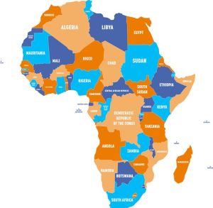
A political map is a type of map that primarily displays boundaries and features related to political or administrative divisions of geographic areas. These maps are designed to provide information about countries, states, regions, cities, and various political units and their borders. The key features of a political map include:
Borders: Political maps prominently show international borders, state or provincial boundaries, and, in some cases, city or municipal boundaries. These lines help users understand the divisions of land areas into distinct political or administrative entities.
Countries and States: Political maps typically display the names and boundaries of countries, states, and other recognized political entities. They help users identify the locations and sizes of these regions.
Capital Cities: The capital cities of countries or states are often marked on political maps with distinct symbols or labels. This provides essential information about the administrative centers of these areas.
Major Cities: Large or significant cities within political divisions may also be labeled or marked on the map to help users identify population centers.
National and Regional Capitals: In addition to capital cities, regional or state capitals may be indicated on the map.
Other Political Features: Depending on the map’s level of detail, it may include other political features such as county lines, district boundaries, or electoral divisions.
Labels and Names: Political maps use labels, names, and text to provide information about the locations and names of political divisions, cities, and other political features.
Political maps are widely used in education, government, international relations, and general geographical reference. They help people understand the political and administrative structure of different regions, making them valuable tools for a wide range of purposes, including planning, decision-making, and understanding the world’s political landscape.
Components of a Political Map
Borders and Boundaries
Political maps delineate the borders and boundaries that separate one political entity from another. They help us identify where one nation ends, and another begins, offering a clear view of national territories.
Don’t Forget to Check Out Our Website: universalbrowse
Capitals and Major Cities
One of the essential features of political maps is the display of capital cities and major urban centers. These are often marked with distinct symbols or labels, making it easy to spot the hubs of political and economic activity within a country.
Geographic Features
In addition to political boundaries, these maps also showcase prominent geographic features such as rivers, mountains, and lakes. These natural landmarks add context to the political landscape, helping us understand how geography influences political decisions.
National Flags and Symbols
Political maps often include national flags and symbols, offering a visual representation of a country’s identity. These symbols serve as a reminder of the unique culture, history, and values of each nation.
Historical Significance
Historical Evolution of Political Maps
The history of political maps dates back centuries. Early cartographers painstakingly created maps by hand, and these maps evolved over time. Maps were instrumental in shaping the course of history and exploration. Read more: What is Fracking in Politics
Key Milestones in Mapmaking
Throughout history, mapmaking achieved significant milestones. The Age of Exploration, for instance, led to more accurate maps, allowing explorers to navigate the world’s oceans with greater confidence.
Influential Cartographers
Many cartographers made significant contributions to the world of political mapping. Ptolemy, Gerardus Mercator, and Abraham Ortelius are just a few of the notable figures who left an indelible mark on mapmaking.
How to Read a Political Map
Understanding a political map requires familiarity with key elements:
Legends and Keys
Maps often feature legends or keys that explain the meaning of symbols, colors, and lines used on the map. These legends are your guide to interpreting the map accurately.
Interpretation of Colors and Symbols
Different colors and symbols represent various features on a political map. For example, blue may indicate bodies of water, while red might signify political boundaries. Interpretation is crucial for extracting information.
Understanding Scale and Distance
Maps have scales that indicate the relationship between the map and the real world. Understanding the scale is essential for estimating distances and planning journeys accurately.
Modern Applications
In the digital age, political maps have found new and diverse applications:
The Role of Political Maps in the Digital Age
With the advent of technology, political maps have gone digital. They are now easily accessible on various devices, making it simpler for people to explore the world from the comfort of their homes.
Use Cases in Politics, Education, and Business
Political maps are integral in politics for understanding voting patterns, demographics, and election results. In education, they aid students in learning about the world’s countries and geography. Businesses use political maps for market analysis and strategic planning.
Conclusion
In conclusion, political maps play a crucial role in our understanding of the world. They provide a visual representation of political boundaries, geographic features, and cultural identity. These maps have a rich historical background and continue to evolve in the digital age. By learning how to read and interpret political maps, we can gain insights into politics, history, and the world around us.
Frequently Asked Questions
Q. What is the primary purpose of a political map?
A. A political map’s primary purpose is to display political boundaries, national capitals, major cities, and other political features of the world.
Q. How do I interpret the colors and symbols on a political map?
A. You can interpret the colors and symbols on a political map by referring to the legend or key provided on the map. This legend explains the meaning of each symbol and color used
Q. Who were some of the influential cartographers in the history of mapmaking?
A. Influential cartographers include Ptolemy, Gerardus Mercator, and Abraham Ortelius, who made significant contributions to the field of mapmaking.
Q. What are the modern applications of political maps?
A. In the digital age, political maps find applications in politics, education, and business, serving various purposes like election analysis, geography education, and market research.
Q. Where can I access political maps online?
A. You can access political maps online through various websites and mapping platforms.